The Burragorang is a name used by the Gundungurra people for the valley areas of the lower Nattai and lower Cox’s Rivers and much of the Wollondilly River Valley (Barrett 1995). The Burragorang lies within the Warragamba Catchment Area situated approximately 70 km south-west of Sydney. Deb Andrew gave a talk to the Society on 27 May 2019. Her Powerpoint presentation can be downloaded below.

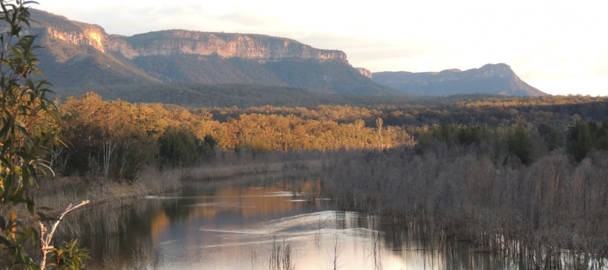
Former Office of Environment and Heritage Scientist, Deb Andrew knows the restricted Burragorang Valley well having worked with members of Oatley Flora and Fauna Society members and Bird Life Australia over many years. The water catchment area of Warragamba Dam one of the most intact grassy box woodlands in south-east Australia, have revealed rare and threatened woodland birds (like the critically endangered regent honeyeater that breeds there). Platypus and rakali inhabit the streams and rivers of the Wollondilly, Nattai and Kowmung. Populations of kangaroos, wallabies (including the endangered brush-tailed rock wallaby) and emu live in a natural equilibrium with their predators the wedge-tailed eagle, dingo and spotted-tailed quoll. It is an area of outstanding biodiversity, but the grassy woodlands of Burragorang are now threatened by the proposal to raise the Warragamba Dam wall and flood more of the valley.

The Aboriginal people of the Burragorang are part of the Gundungurra nation who occupied the watersheds of the Cox and Wollondilly Rivers, extending east to Picton and Mittagong and west to the Kowmung and Abercrombie catchments (Barrett 1995, DECC 2007).
Barrallier in 1802 noted their use of boomerangs which he said were not used by the Sydney Aboriginals (Barrett 1995).
The Aboriginal population of the Burragorang declined and by the 1840’s it was thought fifty or sixty Aboriginal people were camped throughout the valley (Billy Russell in Barrett 1995).
By 1897 the school at the Aboriginal settlement at Pocket Creek on the Cox’s River was closed and the last resident family was transferred to La Perouse Reserve by 1918 (Barrett 1995).

The construction of Warragamba Dam began in 1948 after the severe drought of 1934 -1942 and was completed in 1960 (DECC 2007). The dam created the impoundment of Lake Burragorang which flooded a large part of the Burragorang area, over 10,000 hectares from the Wollondilly River to the junction of the Cox’s and Kowmung Rivers and part of the lower Nattai River (DECC 2007).
The impoundment flooded whole settlements, farming lands, woodlands and riparian forests. The dam wall prevented the breeding movements of native fish to the rivers upstream of the impoundment (DECC 2007, Barrett 1995).
The proposed raising of the Warragamba Dam wall by 14 m for flood mitigation will flood a further 4,700 hectares of the Warragamba catchment and 65 km of wild rivers. This falls within the Blue Mountains and Nattai National Parks, which are part of the World Heritage Area, and parts of the Yerranderie and Burragorang State Conservation Areas. Much of the area to be flooded supports grassy woodland and dry open forest ecosystems identified as priority conservation habitats by the NSW National Parks and Wildlife Service. There is concern for the loss of threatened woodland ecosystems, threatened species, wild rivers, declared wilderness, Aboriginal Heritage and World Heritage Areas.
Watch film ‘Give a Dam’
The film investigates the NSW State government’s controversial proposal to raise the dam wall by 14 metres.

Do You Give a Dam ? What You Can Do to Help?
Check “Give a Dam” website to keep up with news on the campaign at: www.giveadam.org.au
- Sign Petitions
- Attend marches and Events